Year 2006 – 2007
Leonid Appel, Michael Chojnacki, Gali Nir, Natalie Frenkel, Tomer Schwartz, Evgeny Gladshtain, Mark Yagudayev
Faculty of Aerospace Engineering, Technion – Israel Institute of Technology
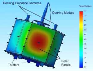
Until recently, on-orbit servicing of spacecraft was a difficult and complex task in space engineering. This year Orbital Express team first successfully demonstrates in orbit the mission ability to satellite servicing: autonomous capture, video survey of a spacecraft, transfer of fuel to satellite, robotic transfer of a battery and computer. Results show that such satellite mission would be far more cost effective than making an otherwise functional large satellite and purchasing its replacement. The TOOLSat project is one of several steps toward developing a system that will extend operation of various types of spacecraft. The word “TOOLSat” presents an abbreviation of student project full name “Technion On-Orbit Lifeguard Satellite”.
Year 2009
Brookman Orly, Podolsky Tatyana, Azar Elad, Ben-Yaakov Ohad, Fligelman Eli , Ben Meleh David, Kfir Rafi
Faculty of Aerospace Engineering, Technion, Israel
A formation of a mother satellite and 4 daughter NANO-satellites in near- GEO will provide permanent access to positioning and precise timing service within the Middle East region. Daughters relay mother’s signals to the user thus providing a user with a set of pseudo-range data. The daughters (<9 kg each) will be built from ‘on the shelf’ components. All satellites will be delivered in orbit in one launch.
Year 2008
Ran Qedar, Natan Grinfeld, Georgy Bezrodny, Ortal Reuven, Alex Tatievsky
Faculty of Aerospace Engineering, Technion – Israel Institute of Technology
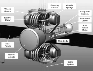
Our mission was to design a space elevator, including all of its sub systems:
1) The cable itself materials, deployment and wave propagation analysis ;
2) Cable car riding on the cable design and analysis.
3) A return vehicle released from the cable design and re entry estimations.
All of these sub systems were combined to the idea we called Jacob s Ladder in order to provide a cheaper alternative to the currently used rocket based ways of transportation between the Earth and the Moon, thus allowing to import large amounts of He3 that can be used as a good source of energy to the planet.
Year 2007-2008
Ben Eliyahu Mordehay , Divekar Rishon, Vax Elad, Chereshchuk Valeria, Shemesh Omri, Ohana Ofek , Ifergan Sara
Faculty of Aerospace Engineering, Technion – Israel Institute of Technology
In the field of Earth observation, present day users and stakeholders impose stringent demands on spaceborne imaging systems, as very high resolution optical, very high resolution SAR imaging. By combining these new constellations with existing systems, overall performance will be significantly improved. Similar formation flying of two observation satellites (optical-optical, SAR-optical, SAR-SAR) were developed recently. For the same purposes in the present project attempt to create the small satellite capable to carry payloads of both categories, optical as well as microwave.

Year 2005-2006
Gilad Rossmann, Tsahi Aviv, Kfir Sella, Maxim Katz, Naama Levy, Suhad Zoabi, Or Berkowitz, Jack Lavan, Noam Vowell, Alex Yudilevich
Faculty of Aerospace Engineering, Technion – Israel Institute of Technology
Stereoscopy in space is the spatial three-dimensional or “stereo” observation of related 2-D images, showing the same object under different viewing angles. The Earth stereo images from orbit enable map-making for many civil and military applications. At present time the stereo plotting application amounts 11% from all spaceborn Earth observation and the needs for topographic data in the world steadily rising. However, stereo space observation ability is very restricted, the satellites with stereoscoping imaging sensors are large, heavy and expensive. In this connection, the enlargement of space observation system capability to acquiring imagery for Earth stereoscopic coverage is very actual task.
Year 2004
E. Hayun, A. Rokach, A. Fertman, G. Hajaj, H. Werner, Y. Cohen, A. Skorohod, A. Novikov, V.Shimankov, N. Sheinberg, S. Goldin
Faculty of Aerospace Engineering, Technion – Israel Institute of Technology
The scientific objective of the student’s project mission LUNGRA (LUNar GRAvity) is the precise mapping of the lunar gravity field, based on satellite-to-satellite tracking. Theoretical and experimental studies have established that two or more co-operating satellites can provide more accurate gravity model. The educational goal of the LUNGRA student project was to demonstrate capability in the development of a very low mass, low power, low volume, and a low cost nanosatellite, while fulfilling an important and ambitious scientific mission.

Year 2003-2004
D. Rosenberg, A. Goldberg, M. Keidar, N. Kalderon, C.Friedman, I. Gur, Y. Ron, G. Kushnir, L. Ben-Yishay, I.Beigelman, I. Baskin, P. Bruk
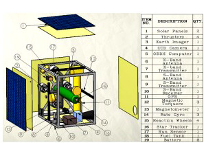
Microsatellite “INSPECTOR” was designed in order to observe the International Space Station (ISS) with high resolution imagery both in the visible and the IR wavelengths during ISS lifetime. The system is operating independently from the Station. It is also capable of observing docked spacecraft, support EVA operations and environmental monitoring. The detection task would be aided by detailed, on-demand images of any region of vehicle’s exterior. The satellite is able to maneuver in the vicinity of ISS, and perform automatic, image-based navigation.
Year 2003
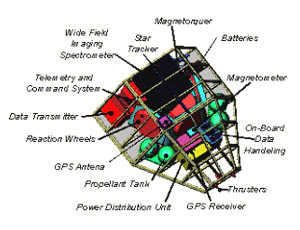
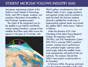
Danna Linn, Ofer Mizrachi, Tamir Bochen, Inbal Sheli, Michael Sandler, Sergy Irlin, Itay Sason, Ronen Golshmid
The OKEV microsatellite is a student project to design a scientific mission, which uses hyperspectral wide field imaging in exploring marine and coastal environments. In order to better utilize the hyperspectral instrument it was suggested to place OKEV in orbit with an existing “On – going” constellation of Earth remote sensing satellites. OKEV operates in a circular sun synchronous Earth repeating orbit (altitude 705 km, inclination 98.2º) as part of the AM-Train formation, which consists of 4 currently in orbit satellites: Landsat 7, EO-1, SAC-C, and Terra. OKEV crosses the equator at 10:07 local time. It is six minutes after EO-1 and usually four minutes before SAC-C. The several simulations for OKEV’s orbit calculation, analysis and visualization were fulfilled using Satellite Tool Kit (STK-5.0) produced by Analytical Graphic, Inc. (AGI).
